Pro Version
SPx Radar Coverage Tool Pro uses a combination of terrain information and line-of-sight calculations to estimate the visibility of targets at given heights, as seen by radars at user-specified locations. Because the tool is using geometric line-of-sight calculations, the coverage map generated may equally apply to optical sensors located at the same sites.
This version of the tool is a licensed product which requires either a unique licence file to be installed on the host machine or a USB licence dongle to be connected to it. The price for a Radar Coverage Tool Pro licence is £500 (ex VAT), when supplied as a MAC address licence file. Alternatively, the RCT Pro can be ordered as a USB dongle option for the price of £950 + shipping. If you would like this option, please contact Cambridge Pixel for a quote, stating whether you wish to arrange shipping yourself or for Cambridge Pixel to arrange shipping (chargeable). RCT Pro on a USB dongle is shipped EXW and you will be responsible for any inward customs charges and for arranging customs clearance.
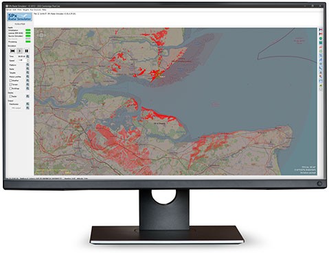
Radar Coverage
Shuttle Radar Topography Mission (SRTM) terrain data is used to calculate the radar visibility. This dataset covers the whole world, with a resolution of approximately 90m for the version used in the free Radar Coverage Tool. The resolution of data used in the professional version is approximately 30m. Additionally, the professional version of the software includes support for using DTED data files as the source of terrain data. For even higher definition requirements, for example airport installations or camera security projects, a special version of the software is available that provides GeoTIFF data support. Radar Coverage Tool Geo supports use of GeoTIFF digital surface model (DSM) data, which may have sub-metre elevation data spacing. Please contact Cambridge Pixel for more information about this version.
The professional version allows radar coverage information to be calculated for up to 10 radar sites, simultaneously, and for the resultant coverage map to be exported to a KML file. This enables the coverage map data to be displayed in third party GIS systems that support KML format, such as Google Earth.
Radar Parameters
The position and height of the radar are specified, together with the end range, top beam angle and bottom beam angle. Targets that would be above or below the beam are deemed not to be visible. The parameters for each of the radar objects may be set independently.
The units used to display heights and distances may be toggled between "Metric" (metres for height and distance) and "Feet, NM" (feet for height and nautical miles for distance).
Radar and Target Modelling
The SPx Radar Coverage Tool is not a modelling tool. It does not use target cross-section and radar characteristics to predict detection. It uses line-of-sight processing to consider whether a target is potentially visible to the radar based on the beam of the radar, height of the radar and target and presence of terrain.
Target Heights
Multiple target heights may be specified with each height being assigned a colour. The transparency of the first colour used is configurable, with the other colours being gradually more transparent as they represent higher target heights. The areas on the map shown in this colour are where targets at the associated height would be line-of-sight visible to the radar, and within the top and bottom beam angles. Target heights may be specified as above sea level or above local ground level.
Underlay Map
The SPx Radar Coverage tool displays coverage information overlaid on an OpenStreetMap view. The professional version also includes support for SkyVector aeronautical chart display. A snapshot of the current view may be saved to an image file using the "Save Screenshot…" button.
New Features Added
Added support for simulated buildings, either manually defined or using Shapefiles.
- Support for up to 10 simultaneous radar positions
- Export coverage information to KML (e.g. for overlay on Google Earth)
- Editable configuration file support
- Setup Wizard
- SRTM1 (~30m) terrain data
- DTED terrain data support
- GeoTIFF elevation data support (Radar Coverage Tool Geo - please consult factory)
- Support for SkyVector aeronautical charts
- No adverts
- Easy selection of radar position:
- Enter lat/long directly
- Click on high-resolution map
- Direct input of radar height
- Map and terrain data downloaded from Internet as needed
- Adjustable radar height, end range and vertical beam angle
- Significant worldwide coverage (based on Shuttle Radar Topography Mission data)
- Configurable target heights-of-interest using different colours
- Fast update of coverage map as position or parameters are changed
- Save display to file
- Curvature of earth consideration
- Adjustable brightness and contrast of map and radar coverage
- Metric or nautical units